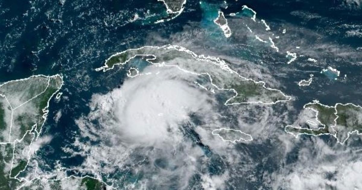
Instituto de Meteorología (INSMET) of Cuba has announced that the passage of Hurricane Beryl this Thursday through the southern seas of Cuba will increase wind strength in the central and western regions of the island.
"From this morning, wind strength will increase in central and western Cuba, with speeds ranging between 20 and 35 km/h, reaching up to 40 km/h with higher gusts, especially in the Isla de la Juventud and the far west of Pinar del Río," warned INSMET in its Tropical Cyclone Warning No. 10.
Regarding precipitation, the central and western regions will experience intervals of showers and rain due to the outer rainbands, along with some thunderstorms, which could be strong in some localities.
There will be strong swells in the southern seas of the central and western regions, particularly in the south of the Canarreos Archipelago, Isla de la Juventud, and the far western part of Cuba, with slight coastal flooding in low-lying areas of this coastline.
In the eastern provinces, where Beryl was felt more intensely on Wednesday, a gradual decrease in wind strength is expected, with winds still coming from the east at speeds between 25 and 40 km/h, with higher gusts.
Rainfall in the eastern region will also decrease throughout the morning of July 4, with only isolated showers in the afternoon.
In recent hours, Beryl has continued to weaken and now has maximum sustained winds of 195 km/h, with higher gusts, making it a Category 3 hurricane on the Saffir-Simpson scale, which has a maximum of five categories.
Beryl maintains its rapid west-northwest movement, with a translation speed of 31 km/h. Early Thursday morning, the phenomenon passed by the Cayman Islands with strong winds and dangerous storm surges. As of dawn on Thursday, initial images of winds, rain, and some flooding in the islands have been observed. Beryl is expected to emerge over the southwestern Gulf of Mexico by Friday night and will then turn towards the northwest.
The approach of Beryl to the coast of Quintana Roo in the Mexican Caribbean has emergency services and the general population on high alert as prevention programs are implemented, given that the hurricane is heading directly towards a highly touristy area.
Impact of Hurricane Beryl on Cuba
In light of the forecasted impacts of Hurricane Beryl on Cuba, here are some frequently asked questions and their answers.
What areas of Cuba will be most affected by Hurricane Beryl?
The central and western regions of Cuba, particularly Isla de la Juventud and the far west of Pinar del Río, are expected to experience the most significant impact, including strong winds and potential coastal flooding.
How strong are the winds expected to be in the affected areas?
Winds in the central and western regions of Cuba are expected to range between 20 and 35 km/h, reaching up to 40 km/h with higher gusts, especially in Isla de la Juventud and the far west of Pinar del Río.
What precautions should residents in the affected areas take?
Residents should stay tuned to local weather updates, secure any loose objects outside their homes, and prepare for potential power outages and flooding. It is also advisable to have an emergency kit ready.