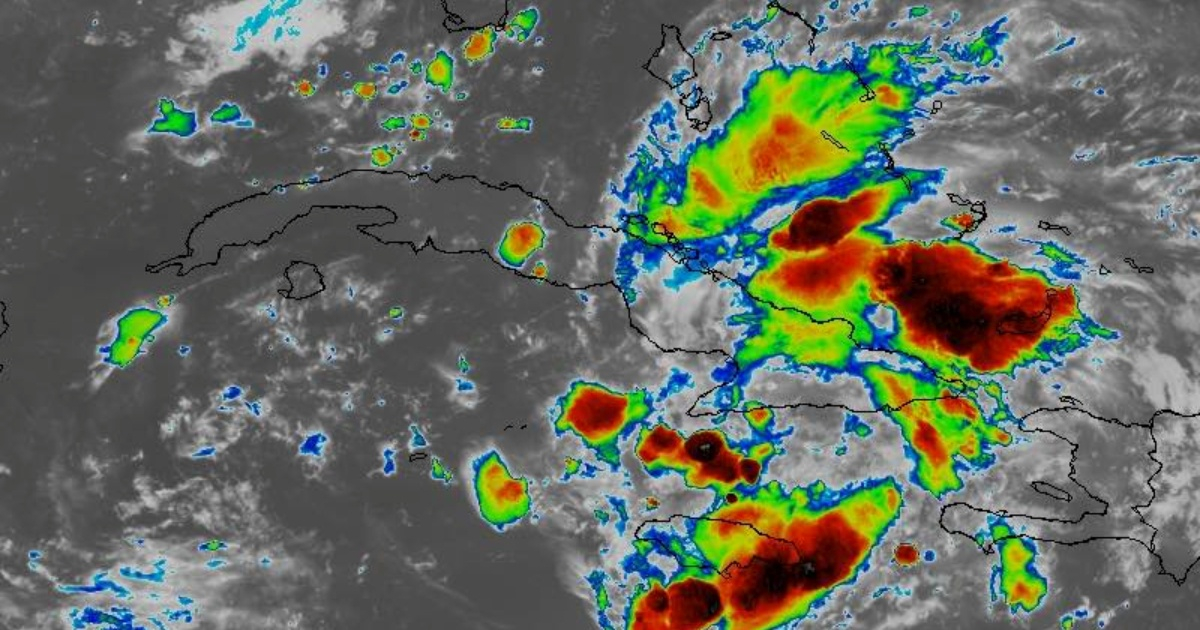
The axis of tropical wave #25, designated as Invest 97L, is causing heavy rain and thunderstorms this Friday in eastern Cuba. The first intense downpours have occurred in the province of Guantánamo, according to Cuban meteorologist Bryam Pérez Valdés via social media. Rain is also falling in Santiago de Cuba.
According to the forecast from the Institute of Meteorology (INSMET) for today, "the eastern region will be mostly cloudy with some rain starting in the morning, extending into the evening, and becoming numerous and strong in some locations." The rest of the country will be partly cloudy, with clouds increasing in the afternoon and bringing rain and thunderstorms from Matanzas to Ciego de Ávila, possibly extending into the night.
Florida on Alert
In its latest bulletin, the National Hurricane Center (NHC) of the United States warned that "a well-defined tropical wave is producing a large area of disorganized showers and thunderstorms over eastern Cuba, Hispaniola, the southeastern Bahamas, and Jamaica, as well as the adjacent waters of the southwest Atlantic and the Caribbean Sea." The NHC specified that the phenomenon is expected "to move near or over Cuba throughout the day and then emerge over the Florida Straits tonight or Saturday."
From that point, environmental conditions will be conducive to the formation of a tropical depression near the Florida Peninsula. The probability of formation within 48 hours is now 60 percent, and over seven days, it rises to 90 percent. The NHC warns that heavy rains could cause areas of flash flooding in Cuba, Florida, and the Bahamas over the weekend.
In anticipation of the possible conversion of the tropical wave into a tropical depression and the associated heavy rains, Florida Governor Ron DeSantis declared an emergency for 54 counties in the state. Miami-Dade is not included among the counties under this alert.
FAQs About the Tropical Wave Impacting Cuba and Florida
Here are some frequently asked questions about the tropical wave currently affecting eastern Cuba and its potential impact on Florida and other regions.
What is the current status of tropical wave #25?
Tropical wave #25, designated as Invest 97L, is currently causing heavy rain and thunderstorms in eastern Cuba.
Which areas are experiencing the most significant impact?
The most significant impact has been reported in Guantánamo and Santiago de Cuba, with heavy rainfall and thunderstorms.
What areas are on alert due to this tropical wave?
The National Hurricane Center has issued alerts for regions including Cuba, Hispaniola, the southeastern Bahamas, and Jamaica. Florida is also on alert, with an emergency declared for 54 counties.
What are the chances of this tropical wave developing into a tropical depression?
The probability of this tropical wave developing into a tropical depression is 60 percent within 48 hours and 90 percent over the next seven days.
