As the peak of the hurricane season approaches, the North Atlantic, Caribbean Sea, and the Gulf of Mexico are showing five disturbances that, despite low development probabilities, are being closely monitored by the National Hurricane Center (NHC) of the United States.
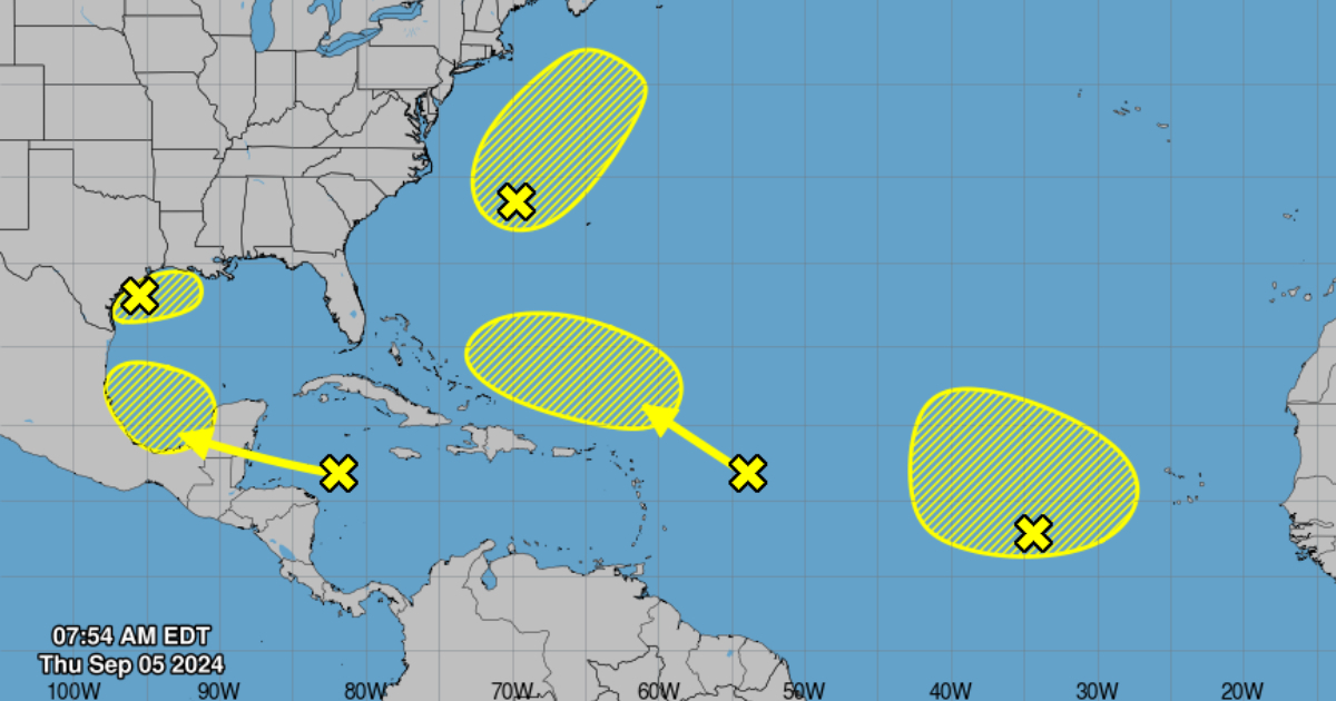
In the northwestern Gulf of Mexico, a trough of low pressure is causing disorganized showers and thunderstorms near the coasts of Louisiana and Texas. Although upper-level winds are expected to inhibit its development in the coming days due to an approaching front, cyclonic development is unlikely, the NHC warned. Nonetheless, the entity warned of heavy rainfall expected in parts of the northern Gulf coast, with a 10% chance of formation both in the next 48 hours and the next seven days.
Meanwhile, in the northwestern Atlantic, a non-tropical low-pressure area situated east of North Carolina is causing disorganized showers and thunderstorms. According to the NHC, there is a possibility that this system could acquire subtropical characteristics in the coming days as it moves north-northeast, although significant development is not expected after Saturday. The probability of formation in 48 hours is 20%, and it remains at 20% over the next seven days.
In the eastern tropical Atlantic, a broad low-pressure area is generating disorganized storm activity. This system could slowly develop as it moves northwest or north in the coming days, with a 10% chance of formation in the next 48 hours and 20% over the next seven days.
In the northwestern Caribbean Sea and southwestern Gulf of Mexico, a tropical wave is moving westward, causing light rain and thunderstorms. Although development is unlikely before reaching Belize and the Yucatán Peninsula by Friday, there is a small chance of development once it emerges in the southwestern Gulf of Mexico over the weekend. The probability of formation in 48 hours is nearly zero, but it increases to 30% over the next seven days, the NHC noted.
Finally, the monitoring center marked a tropical wave in the central Atlantic, east of the Leeward Islands, which shows minimal rain and thunderstorm activity. However, strong upper-level winds are limiting its short-term development. Starting next week, conditions could become more favorable for slow development in the southwestern Atlantic. The probability of formation in 48 hours is nearly zero, and it remains low at 10% over the next seven days.
Cuban meteorologist Raydel Ruisanchez warned this Thursday on Facebook that “we are less than a week away from the peak of cyclonic activity, and so far everything has been quite calm, but this is expected to change.” Evidence of this "peak" is that last Tuesday, the NHC warned that they were monitoring three tropical waves in the Atlantic and Caribbean Sea, noting that they had the potential to become tropical depressions in the Atlantic zone. A few days later, five disturbances are now on the specialists' radar.
Last August, the National Oceanic and Atmospheric Administration (NOAA) adjusted its forecast, confirming that up to 13 cyclones could form. The new report reflects a slight but significant adjustment in NOAA's projections, predicting a range of 17 to 24 named storms (winds of 39 mph or greater) and between 8 to 13 hurricanes (winds of 74 mph or greater).
Frequently Asked Questions about Atlantic Hurricane Season
As the peak of the hurricane season nears, there are several questions and concerns regarding the disturbances in the North Atlantic, Caribbean Sea, and Gulf of Mexico. Here are some frequently asked questions to provide clarity and important information.
What is the current status of the disturbances in the Gulf of Mexico?
A trough of low pressure is causing disorganized showers and thunderstorms near Louisiana and Texas. The chances of cyclonic development are low at 10% over the next 48 hours and seven days.
How likely are the disturbances in the Atlantic to develop into tropical storms?
The disturbances in the Atlantic have varying chances of development. For instance, the non-tropical low east of North Carolina has a 20% chance of acquiring subtropical characteristics in the next 48 hours and remains the same over the next seven days.
What is the forecast for the tropical wave in the Caribbean Sea?
The tropical wave in the Caribbean Sea is generating light rain and thunderstorms. Development is unlikely before it reaches Belize and the Yucatán Peninsula, but chances increase to 30% once it emerges in the southwestern Gulf of Mexico over the weekend.