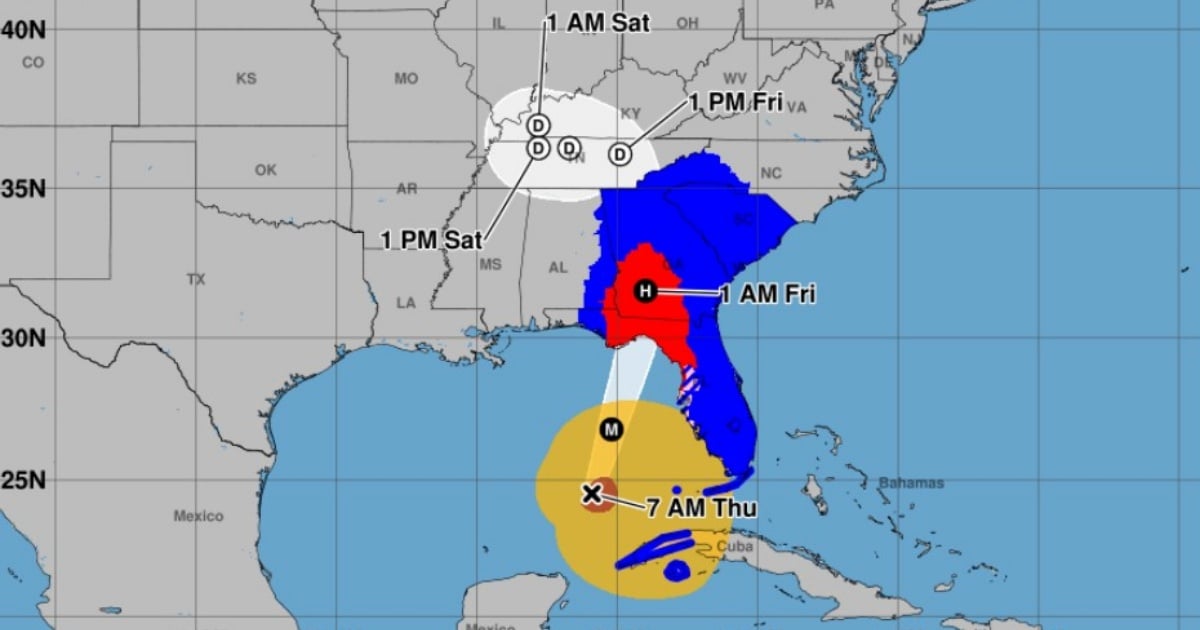
The National Hurricane Center (NHC) has announced that Helene has intensified to a Category 2 hurricane, according to their 7:00 a.m. (local time) intermediate advisory. The storm now boasts maximum sustained winds of 155 km/h (about 96 mph) and is moving north-northeast at 19 km/h (around 12 mph).
Previously, the NHC had warned that Helene could potentially strengthen to a Category 4 hurricane before making landfall on the northern coast of Florida, likely in the Big Bend area, late Thursday night. As of 7:00 a.m., the eye of Helene was located approximately 515 kilometers southwest of Tampa and about 585 kilometers from Apalachicola.
Early Thursday morning, Helene was already bringing heavy rains and strong winds to parts of southern Florida and Cuba. The NHC has cautioned that Helene is a vast tropical system capable of causing severe damage in Florida, with expectations of torrential rains, destructive winds, and dangerous storm surges.
Severe Threats and Warnings
Forecasters are particularly concerned about the increasing risk of life-threatening storm surges and damaging hurricane-force winds along parts of the northern and northeastern Gulf Coast, including Florida's Panhandle and sections of the state's west coast. Even southern Florida will feel the storm's impact, as Helene brings an extensive band of rain and wind.
Storm Surge Warning: In effect from Mexico Beach to Flamingo, covering Tampa Bay and Charlotte Harbor. This means dangerous flooding from rising waters is expected within the next 36 hours.
Hurricane Warning: Active from Anclote River to Mexico Beach, indicating that hurricane conditions are anticipated within the next 36 hours.
Tropical Storm Warning: Issued for the Florida Keys, including the Dry Tortugas, and from Flamingo to Anclote River, affecting various parts of western Florida and northern Cuba (including the Cuban provinces of Artemisa, Pinar del Río, and Isla de la Juventud).
Projected Impacts
Storm Surge: Helene is expected to cause dangerous coastal flooding due to rising sea levels. Impacted areas could see water levels rise between 5 and 20 feet, depending on the location. In southern Pinar del Río, Cuba, water levels might increase by 2 to 4 feet.
Winds: Regions under hurricane warnings could experience destructive winds up to 150 km/h (about 93 mph), with gusts potentially reaching even higher speeds. Tropical storm-force winds are already affecting the Florida Keys and are expected to extend northward along the Gulf Coast.
Heavy Rainfall: Rainfall from Helene could result in accumulations ranging from 6 to 18 inches in the southeastern United States, posing a risk of flash and urban flooding. In Cuba, rainfall could total between 4 and 12 inches, which may also lead to significant flooding.
Tornado Risk: The threat of tornadoes will increase this afternoon, primarily affecting northern Florida, southeastern Georgia, and the Carolinas.
Local authorities have issued mandatory evacuation orders in several vulnerable areas of Florida. Residents in affected regions are urged to follow the instructions of local officials and swiftly complete any preparations to safeguard lives and property.
Conditions will deteriorate rapidly as Helene approaches the coast, making it critical to complete evacuations and preparations by the end of the day.
Tropical Storm Helene initially formed in the northwestern Caribbean Sea on September 24, with forecasts predicting its rapid intensification into a hurricane.