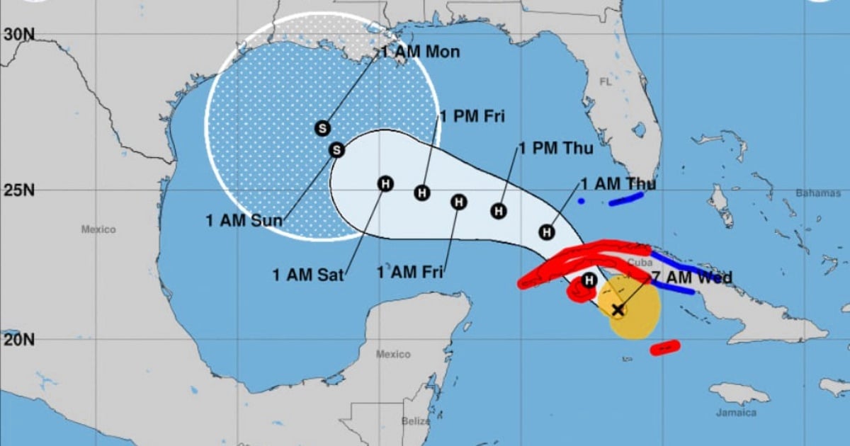
The powerful Hurricane Rafael is gaining strength as it approaches Cuba, now classified as a Category 2 storm with maximum sustained winds reaching 100 mph (160 km/h), as reported by the National Hurricane Center (NHC) in its latest update. Projections suggest that Rafael could intensify further, nearing the status of a "major hurricane"—Category 3—before making landfall in western Cuba.
According to the most recent NHC bulletin, as of 7:00 a.m., Rafael was located approximately 87 miles (140 km) southeast of Isla de la Juventud and 162 miles (260 km) south-southeast of Havana. A hurricane hunter aircraft confirmed the storm's Category 2 wind strength. It is predicted to strike Cuba, potentially hitting Pinar del Río or Artemisa, later today. The hurricane is moving northwest at a speed of 14 mph (22 km/h), with a minimum central pressure of 964 millibars (28.47 inches).
Rafael is expected to impact Isla de la Juventud this morning and proceed toward Cuba's western regions in the afternoon. The storm will maintain its northwest trajectory throughout the day, followed by a shift towards the west-northwest in the Gulf of Mexico. Although it might weaken slightly upon crossing the island, forecasts indicate that it could regain strength in the southeastern Gulf.
Current Warnings and Alerts
Hurricane Warnings are in place for Pinar del Río, Artemisa, Havana, Mayabeque, Matanzas, and Isla de la Juventud. Additionally, a Tropical Storm Warning is issued for Villa Clara, Cienfuegos, Sancti Spíritus, and Ciego de Ávila, extending to the Lower and Middle Florida Keys, from Key West to west of the Channel 5 Bridge, including Dry Tortugas. A Tropical Storm Watch is active for Camagüey and Las Tunas.
Currently, hurricane-force winds extend up to 19 miles (30 km) from the storm's center, while tropical storm-force winds reach out to 102 miles (165 km), impacting a vast area.
Potential Hazards for Affected Regions
Winds: Hurricane conditions are likely in the Cayman Islands soon, with similar conditions expected in western Cuba and Isla de la Juventud today. Tropical storm conditions are anticipated in west-central Cuba and the Florida Keys throughout the day and into the night.
Rainfall: Rainfall accumulations of 4 to 7 inches (10 to 18 cm) are expected in the Cayman Islands and western Cuba, with isolated amounts reaching up to 10 inches (25 cm) in mountainous areas, potentially causing flash floods and landslides. Jamaica and the Florida Keys may see rainfall between 1 to 3 inches (2.5 to 7.5 cm).
Storm Surge: The storm surge could raise sea levels by 1 to 3 feet (30 to 90 cm) above the normal tide in the Cayman Islands tonight and between 8 to 12 feet (2.5 to 3.6 meters) along Cuba’s southern coast in hurricane warning areas, including Isla de la Juventud.
Tornadoes: There is a chance of tornadoes developing in the Florida Keys and southwest Florida mainland during the day.
Surf and Rip Currents: The western Caribbean and Gulf of Mexico are expected to experience large swells, posing a risk of dangerous rip currents.
